# Model running problem
**URL:** https://community.naturalcapitalalliance.org/t/model-running-problem/2059
**Category:** Software Support
**Tags:** sdr
**Created:** [July 17, 2021, 12:01pm UTC](https://community.naturalcapitalalliance.org/t/model-running-problem/2059 "2021-07-17T12:01:14Z")
**Posts on this page:** 15
**Page:** 1
### Author:  [@frank](https://community.naturalcapitalalliance.org/u/frank)
#### Post date: [July 17, 2021, 12:01pm UTC](https://community.naturalcapitalalliance.org/t/model-running-problem/2059/1 "2021-07-17T12:01:14Z")
I got a problem when I was running the model, which is shown as the picture.

---
### Author:  [@swolny](https://community.naturalcapitalalliance.org/u/swolny)
#### Post date: [July 19, 2021, 2:35pm UTC](https://community.naturalcapitalalliance.org/t/model-running-problem/2059/2 "2021-07-19T14:35:59Z")
Hi @frank -
Please post the entire log file (.txt) that the model produces in your Workspace, that may have additional information (like the listing of your data inputs) that can help us troubleshoot.
In general, that error indicates that one of your inputs may have been entered incorrectly, since the model is looking for a raster, but the format of the file is not recognized as a raster.
~ Stacie
---
### Author:  [@jdouglass](https://community.naturalcapitalalliance.org/u/jdouglass)
#### Post date: [July 19, 2021, 4:53pm UTC](https://community.naturalcapitalalliance.org/t/model-running-problem/2059/3 "2021-07-19T16:53:18Z")
Stacie’s absolutely right that the error is coming from something not being able to be opened as a raster, but I’d just like to add that the specific error here is coming from a part of the UI and shouldn’t have anything to do with how the model itself is running … this specific `WARNING` message can be ignored.
But as @swolny mentioned, it would be really helpful if you could attach your logfile from this run of the model so we can see if there was anything else going on here.
James
---
### Author:  [@frank](https://community.naturalcapitalalliance.org/u/frank)
#### Post date: [July 20, 2021, 1:01pm UTC](https://community.naturalcapitalalliance.org/t/model-running-problem/2059/4 "2021-07-20T13:01:38Z")
Appreciate your reply!
I ran the model for several times with the same data, what confused me is that the model doesn’t run successfully everytime, the picture I posted is the situation when I fail to run the model. I upload my successful running file, hope it would help us to figure out the problem.
Thanks
[InVEST-Sediment-Delivery-Ratio-Model-(SDR)-log-2021-07-18–12\_44\_05.txt](https://community.naturalcapitalalliance.org/uploads/short-url/3tDIsLhJqHhIcgR2ov7xZqg7n62.txt) (95.5 KB)
---
### Author:  [@frank](https://community.naturalcapitalalliance.org/u/frank)
#### Post date: [July 20, 2021, 1:03pm UTC](https://community.naturalcapitalalliance.org/t/model-running-problem/2059/5 "2021-07-20T13:03:35Z")
Thanks for your reply.
I have uploaded my logfile in the reply to @swolny .
---
### Author:  [@frank](https://community.naturalcapitalalliance.org/u/frank)
#### Post date: [July 20, 2021, 2:10pm UTC](https://community.naturalcapitalalliance.org/t/model-running-problem/2059/7 "2021-07-20T14:10:27Z")
Dear @swolny
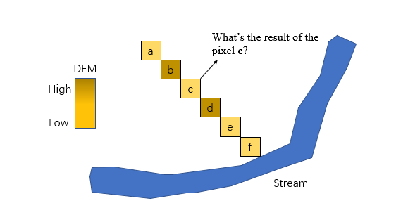
I also have question about the theory of the model. How the model compute if the slope radian is a nagetive value and the sediment doescn’t reach the stream? Please see the attached picture.
---
### Author:  [@swolny](https://community.naturalcapitalalliance.org/u/swolny)
#### Post date: [July 20, 2021, 2:27pm UTC](https://community.naturalcapitalalliance.org/t/model-running-problem/2059/8 "2021-07-20T14:27:15Z")
Hi @frank -
Has anything changed with your inputs between the model runs that work and the runs that don’t? It would be useful to see a log file from one run that works and one run that doesn’t.
I’ll defer model theory to @jdouglass or someone else who knows the code well. It would be interesting to know what happens in those cases where a flow path does not reach the stream, or hit a NoData pixel, but gets stuck in a pit (if I’m interpreting your question correctly). I know that the model does a very simple fill of major pits, but there are surely many cases where there is a natural divot in the landscape, or other reason that sediment would reach a non-stream point and not get any further.
~ Stacie
---
### Author:  [@frank](https://community.naturalcapitalalliance.org/u/frank)
#### Post date: [July 20, 2021, 2:37pm UTC](https://community.naturalcapitalalliance.org/t/model-running-problem/2059/9 "2021-07-20T14:37:26Z")
> [@swolny](#):
>
> I know that the model does a very simple fill of major pits, but there are surely many cases where there is a natural divot in the landscape, or other reason that sediment would reach a non-stream point and not get any further.
It seems that I have deleted the failed file, but I’ll keep it when I run into the same problem. Would the sediment be an output if it reaches a non-stream point?
---
### Author:  [@jdouglass](https://community.naturalcapitalalliance.org/u/jdouglass)
#### Post date: [July 20, 2021, 5:19pm UTC](https://community.naturalcapitalalliance.org/t/model-running-problem/2059/10 "2021-07-20T17:19:52Z")
> [@frank](#):
>
> I ran the model for several times with the same data, what confused me is that the model doesn’t run successfully everytime, the picture I posted is the situation when I fail to run the model. I upload my successful running file, hope it would help us to figure out the problem.
Actually, could you provide the logfile from when the model _didn’t_ run? That will be very helpful in trying to see if there was an issue.
---
### Author:  [@jdouglass](https://community.naturalcapitalalliance.org/u/jdouglass)
#### Post date: [July 20, 2021, 5:25pm UTC](https://community.naturalcapitalalliance.org/t/model-running-problem/2059/11 "2021-07-20T17:25:24Z")
> [@swolny](#):
>
> I’ll defer model theory to @jdouglass or someone else who knows the code well. It would be interesting to know what happens in those cases where a flow path does not reach the stream, or hit a NoData pixel, but gets stuck in a pit (if I’m interpreting your question correctly). I know that the model does a very simple fill of major pits, but there are surely many cases where there is a natural divot in the landscape, or other reason that sediment would reach a non-stream point and not get any further.
The model will fill _all_ hydrological sinks (including very large sinks and 1-pixel ‘divots’), so that’s everything where water would not flow out. So then @frank if pixel `c` in your chart is a hydrological sink (all surrounding pixels are higher than `c`), the model will raise the pixel value of `c` so that it drains into the nearest downward pixel. In this case it might be `d`, but it also depends on the other surrounding pixels. The end result will be that the flow path from `a` would reach the stream.
Nodata holes are not filled, though … those are left alone as nodata, but be forewarned that the flow path may flow in to the nodata hole.
---
### Author:  [@frank](https://community.naturalcapitalalliance.org/u/frank)
#### Post date: [July 21, 2021, 2:44am UTC](https://community.naturalcapitalalliance.org/t/model-running-problem/2059/12 "2021-07-21T02:44:12Z")
Thank you, It’s very helpful.
---
### Author:  [@frank](https://community.naturalcapitalalliance.org/u/frank)
#### Post date: [July 21, 2021, 2:46am UTC](https://community.naturalcapitalalliance.org/t/model-running-problem/2059/13 "2021-07-21T02:46:26Z")
I’m sorry I have deleted the file when the model fail to run, but I’ll keep it next time.
---
### Author:  [@frank](https://community.naturalcapitalalliance.org/u/frank)
#### Post date: [July 21, 2021, 2:58pm UTC](https://community.naturalcapitalalliance.org/t/model-running-problem/2059/14 "2021-07-21T14:58:28Z")
Hi @swolny
I get the model results with usle, export and deposition, but they are all .tif format with no attribute tables. I tyied to extract the raster to point to get the value of each pixel (I’m doing this process), maybe I’ll change the type of the value field to get the arttribute table. I just would like to know how you guys process the model results.
Thanks.
---
### Author:  [@swolny](https://community.naturalcapitalalliance.org/u/swolny)
#### Post date: [July 21, 2021, 3:41pm UTC](https://community.naturalcapitalalliance.org/t/model-running-problem/2059/15 "2021-07-21T15:41:59Z")
Hi @frank -
I’m glad that you got the model to run. The raster results are floating point values, and I’ve never seen raster attribute tables supported for floating point types. ArcGIS supports raster attribute tables for data types that are integer, string, etc, but not floating point. QGIS doesn’t support raster attribute tables at all, for any type.
What do you want to do with the results? Most often we make simple maps of sediment export, to see where erosion is being generated in the watershed that’s likely to impact water quality. We may also aggregate sediment export within a watershed, to quantify how much is being delivered to a point of interest at the watershed outlet, like a reservoir or drinking water supply. If we have scenarios, we’ll create change maps to see which areas increase or decrease in erosion due to some future change in management, climate, etc. It really depends on what are the questions or decisions you’re trying to inform.
~ Stacie
---
### Author:  [@system](https://community.naturalcapitalalliance.org/u/system)
#### Post date: [July 28, 2021, 3:42pm UTC](https://community.naturalcapitalalliance.org/t/model-running-problem/2059/16 "2021-07-28T15:42:38Z")
This topic was automatically closed 7 days after the last reply. New replies are no longer allowed.